
Bias Correction in Transportation Research
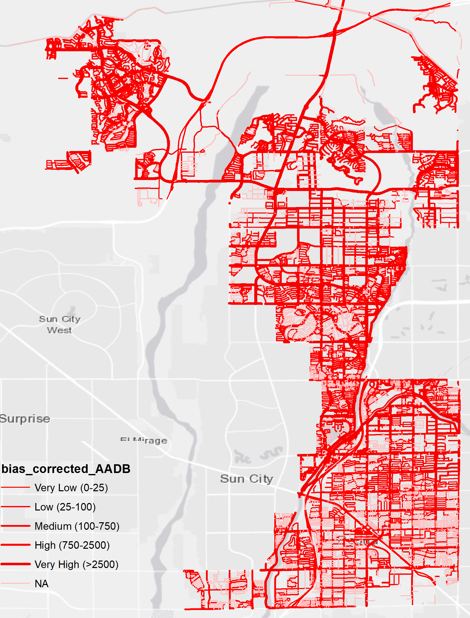
Predictive analytics have systemic biases resulting from sampling issues in data collection pipeline do not always address spatial, racial, and economic inequalities in cities. If not addressed such biases in big data can result in discriminatory policy outcomes and reinforce social disparities in resource allocation across neighborhoods. Our work on bias correction addresses these issues in the urban context. Our research involves developing analytical tools to account for sampling biases in big data from crowdsourced apps. The focus of this work is currently on bicycling movements data to assist fair active transportation planning in cities.
Related Publications:
1. Roy, A., Nelson, T. A., Fotheringham, A. S., & Winters, M. (2019). Correcting bias in crowdsourced data to map bicycle ridership of all bicyclists. Urban Science, 3(2), 62.
2. Nelson, Trisalyn, Avipsa Roy, Colin Ferster, Jaimy Fischer, Vanessa Brum-Bastos, Karen Laberee, Hanchen Yu, and Meghan Winters. “Generalized model for mapping bicycle ridership with crowdsourced data.” Transportation research part C: emerging technologies 125 (2021): 102981.
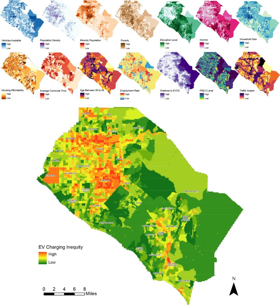
MCDA for Electric Vehicle Accessibility
Decision-making for city planning is driven by insights into how people move from one location to another. Spatial-temporal data can aid transportation planners to improve the way citizens go about their daily commutes without hassle. Our research combines built environment, land-use type, and socioeconomic factors to account for bias-corrected predictions of bicycling ridership in cities. We also look at the equity issues around emerging transportation amenities like spatial disparities in electric vehicle charging stations in the Orange County, California region using decision analysis tools.
Related Publications:
1. Roy, A., & Law, M. (2022). Examining spatial disparities in electric vehicle charging station placements using machine learning. Sustainable Cities & Society. https://doi.org/10.1016/j.scs.2022.103978
2. Roy, A., Nelson, T. A., Fotheringham, A. S., & Winters, M. (2019). Correcting bias in crowdsourced data to map bicycle ridership of all bicyclists. Urban Science, 3(2), 62. https://doi.org/10.3390/urbansci3020062
3. Nelson, T., Roy, A., Ferster, C., Fischer, et al. (2021). Generalized model for mapping bicycle ridership with crowdsourced data. Transportation research part C: emerging technologies, 125, 102981. https://doi.org/10.1016/j.trc.2021.102981
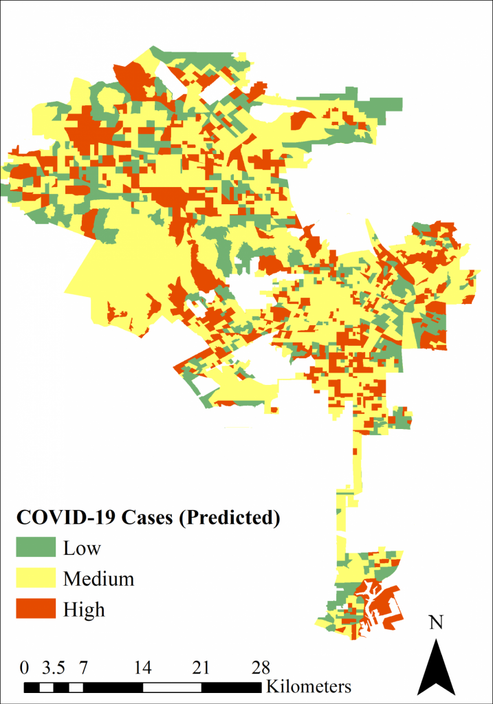
Mapping spatial variability of infectious disease spread
Our COVID-19 project involved developing COVID-19 risk maps at the census block-group levels to understand the spatial variations in the spread of the disease at local scales. We are investigating the combined influence of mobility patterns and sociodemographic factors that can impact the spread and infection rates. We developed social distancing indices and mobility indices from POI data to highlight the spatial variation of human mobility patterns at the census block group level and quantified their effect of COVID-19 risk using machine learning algorithms. We have also studied the vulnerability of human populations in the face of pandemics like COVID-19. Using human mobility data, environmental and socioeconomic factors we categorized the risk into high, medium, and low categories at multiple spatial and temporal scales.
Related Publications:
1. Roy, A., & Kar, B. (2022). A multicriteria decision analysis framework to measure equitable healthcare access during COVID-19. Journal of Transport & Health, 101331. https://doi.org/10.1016/j.jth.2022.101331
2. Roy, A., & Kar, B. (2020, November). Characterizing the spread of COVID-19 from human mobility patterns and Sociodemographic indicators. In Proceedings of the 3rd ACM SIGSPATIAL international workshop on advances in resilient and intelligent cities (pp. 39-48). https://doi.org/10.1145/3423455.3430303
Built environment characterization from UAVs
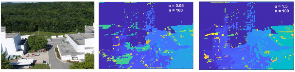
Improving our understanding of the spatial distribution of urban built environment is essential for informing urban resource, waste, and environmental management. However, it is often difficult owing to the inaccuracy and inconsistency of the typology and material composition data of buildings and infrastructure. Our research focuses on building a Bayesian clustering approach based on spatial proximity for segmenting images from LiDAR to classify the built environment.
Related Publication:
1. Roy, A, Casleton EJ, Fairchild G, Ray W, Stinson BJ, Duncan AJ (2022). Built environment characterization from fused UAV imagery using nonparametric clustering. In GIScience and Remote Sensing (Under Review) Preprint: https://doi.org/10.36227/techrxiv.18585356.v1
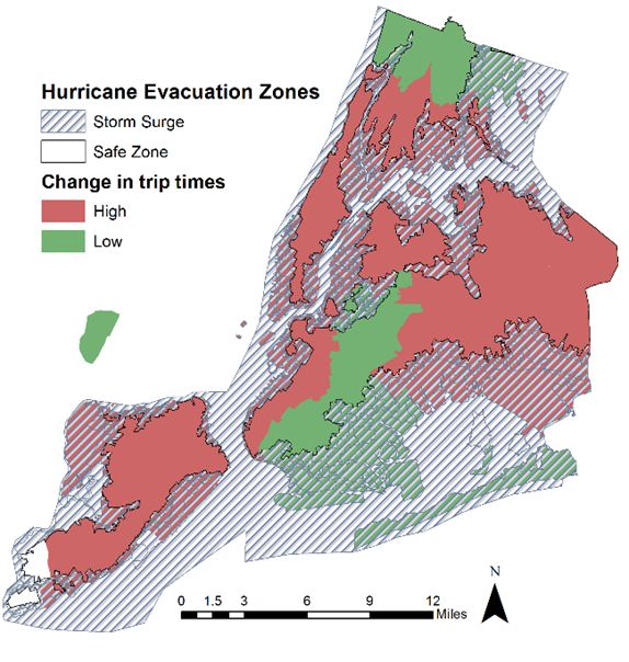
Mapping evacuation zones during extreme events
Exploring the effects of natural hazards on the spatial and temporal patterns of transportation movements can reveal areas of high risk. It also enables researchers and policymakers strategize efforts to reduce exposure of vulnerable populations during such catastrophic events and emergencies. Our research explores the associations of traffic movements along with natural hazards like hurricanes and how they disproportionately affect certain urban populations who are more vulnerable.
Related Publication:
1. Roy A, Kar B (2022). Effect of social vulnerability on taxi trip times during hurricane Sandy. In Transport Findings https://doi.org/10.32866/001c.53070.
Funding Sources
Our projects have been generously supported by the following funding agencies:
- California Department of Transportation (CalTrans).
- Statewide Transportation Research Program (STRP), State of California Road Repair and Accountability Act (SB1).
- University of California National Laboratory Fees Program. (Website: https://wetlands.ucsc.edu/people.html)
- John F Randolph and Dora Haynes Foundation Faculty Fellowship.