 WULF (Wildland-Urban uLtrahazardous Flooding) is a multi-year project funded by NSF (2021-2024) in collaboration with Brett Sanders (PI) focused on understanding post-wildfire flooding hazards along the wildland-urban interface (WUI) in Riverside County. I lead WULF’s risk perception component to understand the hazard perception of residents living along the WUI and urbanized lowlands below mountain catchments who can be exposed to ultrahazardous flooding characterized by rapid-onset, high-velocity, erosive, debris-laden flooding with unpredictable flow paths after fire events. WULF will be carried out in partnership with public works and emergency management agencies.
Santa Ana Neighborhood Change Study. Despite growing concerns over gentrification, understanding how nearby residents feel about transit-induced neighborhood change remains understudied. In response, this project surveyed over 325 residents near an existing commuter rail station and the planned OC Streetcar route in Santa Ana, California, a largely low-income, Latinx community. We found residents were on average satisfied with neighborhood access to transport and amenities, but that living adjacent to the Streetcar route was associated with more negative assessments of change, reflecting heightened concerns about housing costs, displacement, and parking.
Put a Park on It. This project provided the first assessment of a planning strategy to mitigate the negative impacts of freeways: cap parks, or decks with parks built in the air space directly above below-grade freeway sections. We assessed the design, function, and placement of freeway cap parks in 24 U.S. cities and found that, although cap parks can help reconnect and green cities divided by freeway construction, planners and developers have largely focused on economic and environmental goals and have sidelined equity concerns related to housing affordability and gentrification.
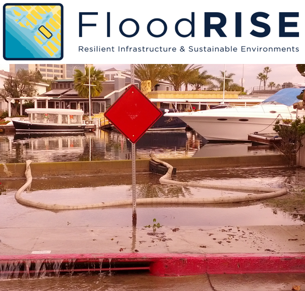 The FloodRISE (Flood Resilient Infrastructure and Sustainable Environments) project (NSF, 2013-2017) examined whether parcel-level flood predictions can catalyze behavioral and policy change in the flood vulnerable communities of the Newport Bay and Tijuana River Estuaries.I led an innovative cognitive mapping survey focused on understanding spatial dimensions of resident flood risk perceptions. We compared participant cognitive mapping sketches of flood-prone areas with the modeled distribution of flood hazards and found that agreement between local and expert knowledge varied by personal and contextual factors. We also found that viewing interactive flood hazard maps affects the spatial flood risk perceptions of coastal residents. The FloodRISE team has also examined the promise and challenge of using collaborative modeling to build flood resilience, the sources from which residents receive flood risk information, and whether co-production of flood hazard maps can meet diverse decision-making needs.
The Expo Line Study. This multi-year, survey-based study (2012-2016) and was the first before-after quasi-experimental evaluation of a light rail investment in California. It examined the impact of the first phase of Metro’s Expo Line (a light rail transit line that began service in early 2012 from downtown Los Angeles to Culver City) on the travel and physical activity patterns of nearby residents. We found that living within walking distance of the new rail service was associated with approximately 10 fewer miles driven per day and that vehicle-related CO2 emissions of these households were 27 percent lower after the opening of the light rail. Living near a station was associated with an increase in walking and physical activity for those who previously had low walking and physical activity. We also found that gender differences in environmental beliefs and safety concerns impacted ridership and resulted in lower female train ridership (J36). This study helps policy makers understand the implications of directing growth towards transit corridors.
Environmental Justice and Air Pollution Exposure. These research initiatives inform transportation, land use, public health, and hazards policy by more precisely characterizing where and when human exposure to air pollution occurs. The Harbor Communities Time Location Study (2011) analyzed 15-second interval GPS-based time-location data to assess traffic exposure across daily locations for residents of the largely low-income, immigrant, and Latino communities near the Los Angeles-Long Beach port complex. The Boyle Heights Activity and Exposure Study (2013) used portable GPS-based tracking and personal air pollution monitoring and found substantial spatial and temporal variation in traffic-related pollution concentrations among residents of the Boyle Heights neighborhood near downtown Los Angeles. My invited editorial in the American Journal of Public Health (2018) drew attention to the detrimental public health and environmental justice impacts of weakening federal particulate regulations proposed at the time. My work also presents a framework for understanding how disparities in traffic exposure are related to structural inequalities embedded in the urban structure, uneven development patterns, and transportation infrastructure. Related publications also characterize air pollution concentrations in critical microenvironments including childcare facilities, residences, rail transit platforms, and sidewalks.